Statewide Affairs:
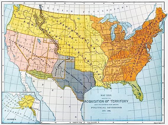
The State of South Dakota, is made up mostly of surface area of which was part of the
Louisiana Purchase when the United States bought the land from France in 1803 for the amount of
$15,000,000 million which was a section of land that contained 827,000 square miles.
Sparin had secretly claimed the territory from France, as part of the 1763 Treaty of Paris of which
ended the Seven Years War, which was a battle between Great Britain, Spain, and France over colonial
power. It was known then as La Louisiane, named after the French King Louis XIV.
Much of the Louisiana Purchase was part of the original earlier land claims first established by the
Vikings, of whom came to the North American Continent long ago, between 900 and 1,000 and before the
rest of the European Continent arrived, of which France had taken the land in 1682. During the
latter stages of the Seven Year War (1666 to 1673), Spain was in the war to expand its territory,
and had taken St. Louis, and Louisiana. The treaty became the main source of authority, of the land
transfer, of which Spain now controls and claimed the area, until 1789, when France again, reclaimed
the area, from Spain, and had owned it up until they had sold it to the United States in 1803 in
need of money in Napoleon's quest to take control of France.

Shortly thereafter, the United States Government sent out Lewis Mayweather, and Clark Williams to
explore the area, a period that took place between 1804 to 1806 with the goal to map, survey, and
explore the massive surface area. Upon this Great Exploration, the Congress began studying the data,
information, the map, leading to to 1841 when it adopts the Preemption Act which allowed early
Americans to go out, seek land, with the intent to lay claim, settle, reside, and work the land for
future development, this all leads the early history of what today, has become the State of South
Dakota.
While the roots of the Town of Sioux Falls, and the State of South Dakota can trace their official
roots from migration of "Pommeranian Farmers" from Europe, this colony of individuals
began to populate the area which now was to be known as Dakota Territory, which later on becomes the
States of South Dakota, North Dakota, Montana, and Wyoming by the end of the 1800's.
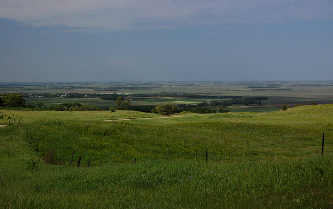
The Eastern side of South Dakota is a vast wilderness area, known as the Coteau De Prairies - the
divide between the paths of two streams of glacial ice during the Wisconsinan glaciation of North
America. It is 200 miles in length, and 100 miles in width, it is a flat ironed-shaped section of
land that rises high above the Missouri Plateau, southwest of the State of Minnesota. On the eastern
edge you have the Big Sioux River Basin, while on its western edge you have the James
River Basin of which this region will play a huge role in the early development of the
"State" as Americans begin to move westward. This area was once known as New France
(Quebec), while Corteau was named after "The Hill".

Anyone who has ever driven across the Eastern half of South Dakota, would notice this rising section
of land as they traveled northbound from Sioux Falls to Fargo, North Dakota. It simply stands out
like a sore thumb as you make your way through the area. A region made up of glacier lakes, streams,
and rivers.
Both the James and Big Sioux Rivers are directly linked, and form their origins in the northeastern
portion of the State, and begin to make their way southward, as they pass through each side of the
"The Hill" of which the begin to pass by the glacier lakes, underground springs beneath
the surface, rolling down the rolling hills as they make it to the Missouri River.
Many of the Cities and early townsite claims began in this area, mostly thanks to the lush river
valleys on both sides - you have Sisseton in the north, Watertown, Aberdeen, Flandreau, Huron,
Brookings, Mitchell, Dell Rapids, to Sioux Falls, all the way south to Sioux City, Iowa.
As for the Western side of the "State" you have nothing but wide open spaces, barren
landscape, mostly devoid of any human life. Many of the townsites are formed across a more wider
land mass, mostly thanks to the topography of the land itself. As you travel the State, you notice
that the land slowly rises the farther west you get, almost like rolling hills rising high above the
Eastern Prairie. The Black Hills are nothing more than a series of hills that are part of the Rocky
Mountain chain, of which form the continental divide that separates the "West" and the
"East" parts of the North American Continent.
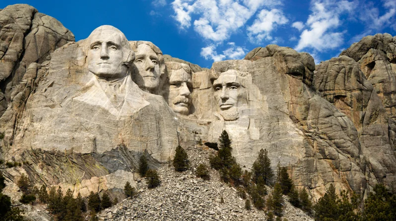
Mount Rushmore was placed on one of the taller peaks in the Black Hills, and has become one of the most precious National Monuments in America today. Built between 1927 and 1967, the location was chosen thanks to creator Gutzon Borglum of whom was friends with Theodore Roosevelt, and had connections to Calvin Coolidge during a period when the National Park System was first being established, while South Dakota was chosen because it was it was one of the favorite hang outs of both Roosevelt and Borglum, while it was Coolidge who visited often to the area.

With a current population of roughly 887,000 American Citizens today, South Dakota is made up of many
faces, from the seven Native American Tribes, to a people of who came from all parts of Eastern
Europe - Germany, Poland, Denmark, Hungary, and the Baltic States, South Dakota is most definitely
known for their Great Faces, Great Places.
The major economic means of the State is Agriculture, Tourism, Finance, and Healthcare, while it is
known as a major Republican Party State, from its inception, it is not as conservative as one may
think, with the residents of the state being more progressive in nature, but grounded in their
faith.
We, the People by means of our ancestors, worked together between 1860 and 1890 to establish a
"State of People" of which All men are born equally free and independent, and have certain
inherent rights, among which are those of enjoying and defending life and liberty, of acquiring and
protecting property and the pursuit of happiness. To secure these rights governments are instituted
among men, deriving their just powers from the consent of the governed, of whom believe the right to
worship God according to the dictates of conscience shall never be infringed. No person shall be
denied any civil or political right, privilege or position on account of his religious opinions; but
the liberty of conscience hereby secured shall not be so construed as to excuse licentiousness, the
invasion of the rights of others, or justify practices inconsistent with the peace or safety of the
state, and of which no person shall be deprived of life, liberty or property without due process of
law. The right of persons to work shall not be denied or abridged on account of membership or
non-membership in any labor union, or labor organization - The Republic of South Dakota
- State Bar Lawyers Want Immunity From The Decisions They Make
- How was the South Dakota Public Education System Established
- Joining Forces to Raise Taxes for Jails
- Shared Parenting Will Never Be Accepted
- What is the South Dakota Legislature Research Council
- Who is responsible to pay sales tax in South Dakota?
- What Constitutes a Public Record?
- The Marijuana Debate
- Voters Adopt Amendment D
- Responsibilities of the Lieutenant Governor
- Certificate of Title Paper Shortage
- Statewide Video Lottery Changes
- Can A Woman Be Found Guilty Of Homicide In Cases of Abortion?
- OUR FUTURE IS BRIGHT AS OUR YOUTH BEGIN TO LEARN THE POLITICS
- What is a Township, and How are they Formed as a Political Subdivision Under South Dakota
- THE STATE OF SOUTH DAKOTA CONSTITUTION ALLOWS FOR THE PEOPLE TO CIRCULATE THEIR OWN CURRENCY


